Ghostrida9
-
Posts
397 -
Joined
-
Last visited
-
Days Won
2
Content Type
Profiles
Forums
Events
Everything posted by Ghostrida9
-
Working a bit on Bagram Airbase... the Fuel Bunkers are missing in DCS, there's also a smaller version at the base.. (model coming soon). so far...

- 1 reply
-
- 2
-

-

-
What can't we release Cold War Germany Phase 2 without?
Ghostrida9 replied to MAESTR0's topic in Wish List
Reduce the Killer High Grass by at least 80%, it's driving me nuts to say the least, should not be difficult to reduce the model file in speedtree and implement it into the scenery file. And please, make the Airbases more accurate before even thinkin' bout Phase 2 or 3, at least the ground tiles and road map, up to the gates of all bases. Google maps, Bing maps will help you alot. Havin satellite images like the Afghanistan map remains a dream... Thanks... -
Eastern propaganda at Pferdsfeld road entrance
Ghostrida9 replied to gulredrel's topic in Bugs and Problems
LOL those billboards are hillarious... even the NATO ones... first time i saw them i burst out in laughter.. i thought about to do a mod with the Southpark cartoon on it.. use the Scenery remove object tool and remove them... -
same goes for Büchel Airbase, and while we at it, the Tower is wrong, the Main Radar Tower is completely missing...
-
Gütersloh Airbase Project (Screenshots & resources)
Ghostrida9 replied to Ghostrida9's topic in DCS: Cold War Germany
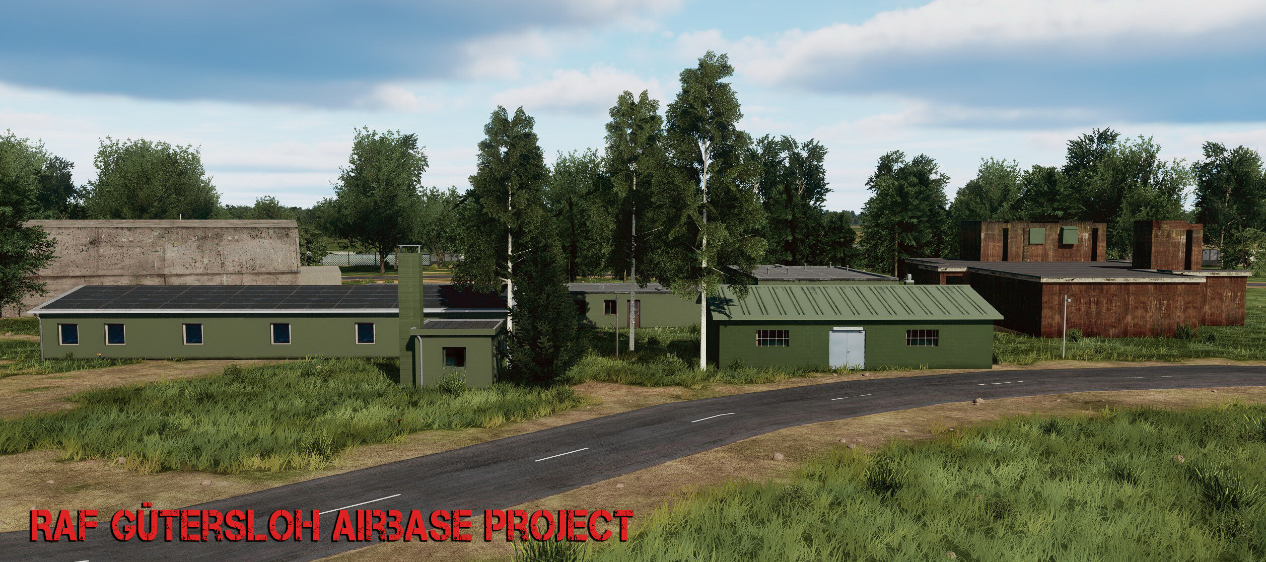
@Esac_mirmidon Thx.. @skywalker22 you probably know the basics but.. 1. Research, research..research 2. Create models and textures / Roughmets/ Normal maps and render them as dds/EDM files 3. create lua files 4. Headache...because you figure that the Airbase/Airport layout is inaccurate... 5. Thinking until you get headache again... 6. Headache..the Killer High grass is drivin you nuts... 7. A lot of trial and error.. Back to work. I'll be away for a week, but some more updates for now.. Again, UGRA has not yet created most of the critical military infrastructure like those huge "grass" bunkers...there're at least 3 of them at Gütersloh, the place is completely empty on their map.. no layout.. nothing !! Creating the ground layout above the "Killer Grass" is really annoying work to say the least...
-
Gütersloh Airbase Project (Screenshots & resources)
Ghostrida9 replied to Ghostrida9's topic in DCS: Cold War Germany
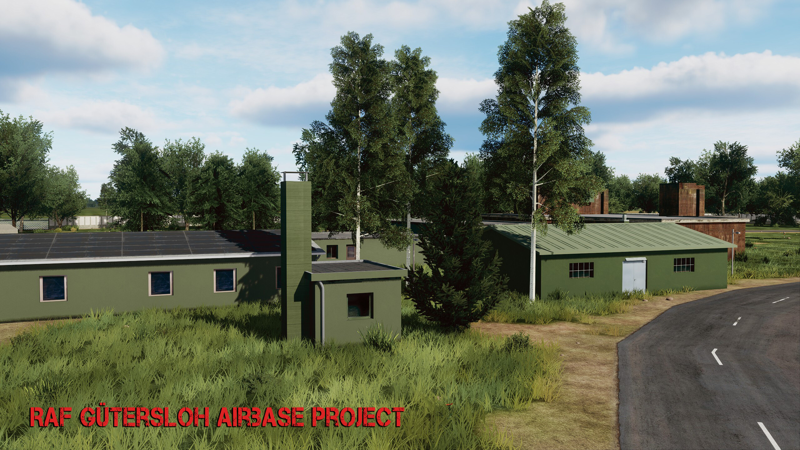
Thanks to all of you, Thx @Manschy, i allready have the "old" shelter door as texture so it's easy to change it, a good idea is to have maybe Hangar 6 and & 7 with the old doors and the rest with the new ones, so it's a bit of the base in it's transition. Regarding inaccuracy.. there's a waste water plant at the base located north west, close to the shelters.. i can understand that Ugra has not created the buildings or something.. ok, but not even creating the concrete ground tiles..?! just trees and thats it !!!!, They should really work with Satellite images, would be much much better. I tryed what i could to create this spot, still small parts of the KILLER HIGH GRASS is coming through... but, anyway you get it..
-
Gütersloh Airbase Project (Screenshots & resources)
Ghostrida9 replied to Ghostrida9's topic in DCS: Cold War Germany
a lot is going on lately but i keep creating my own PBR textures when i get to it, it takes time but the good thing is that many of those textures can be used for many buildings. Just a few more normal maps and roughmets are missing. I also created a few more models allready.. anyway... a small update.. more soon
- 50 replies
-
- 16
-
-
-
yea, but on Airbases, its totally wrong. sure when the base should have that "many years abandoned look" then it's spot on... if this should represent a operational Airbase, then it's all wrong. So far the height of the grass is only accurate for the fields..
-
i fully agree, they should skip Phase II and III so far until the Airbases are fixed, lakes are missing around some bases, the Road map on bases is mostly inaccurate. Spangdahlem looks totally wrong, they even put a german village into the base almost, at a spot where the main gate is, and where storage buildings and military infrastructure should be. Also please add more parklng lots and more accurate detail according mostly to bing or google maps.. the detail we have right now is pretty inaccurate or unnecessary. I hope they give all Airbases a major overhaul. Radar Towers are missing and so much more...
-
Gütersloh Airbase Project (Screenshots & resources)
Ghostrida9 replied to Ghostrida9's topic in DCS: Cold War Germany
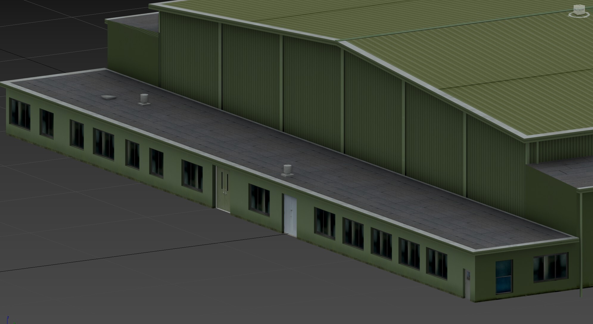
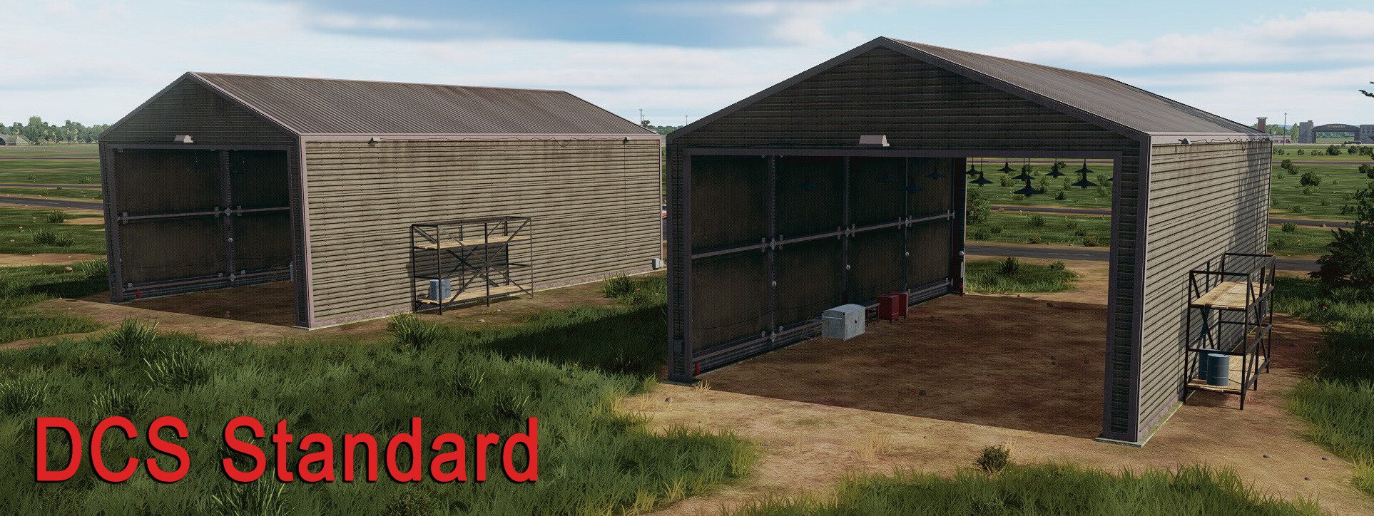
Ugra media has yet not created even one of the major buildings for this Airbase.. hope they skip Phase 2 and 3 until everything looks much more realistic, also the road map on this airbase is kinda off.. again, google maps is your friend to some degree. Same goes for all the other bases so far... work in progress model for the large Main hangars 2, 3, 5, and 6..
-
Gütersloh Airbase Project (Screenshots & resources)
Ghostrida9 replied to Ghostrida9's topic in DCS: Cold War Germany
Thanks a lot !! I had to create my own PBR textures and tryed different colors schemes that would work, I still need a few more but so far, things are going well. For the first time i also played around and created some Roughmets. Sure there's a lot when it comes to the landscape detail itself which is missing, even the small lake which is located north west of the base is missing and yes the Ems river is wrong.. don't know UGRA should work with Google or Bing maps so at the least the landscape and roads would be accurate. The "Killer High Grass" is a problem no matter what you try.. Roughmet..
- 50 replies
-
- 13
-
-
-
Gütersloh Airbase Project (Screenshots & resources)
Ghostrida9 replied to Ghostrida9's topic in DCS: Cold War Germany
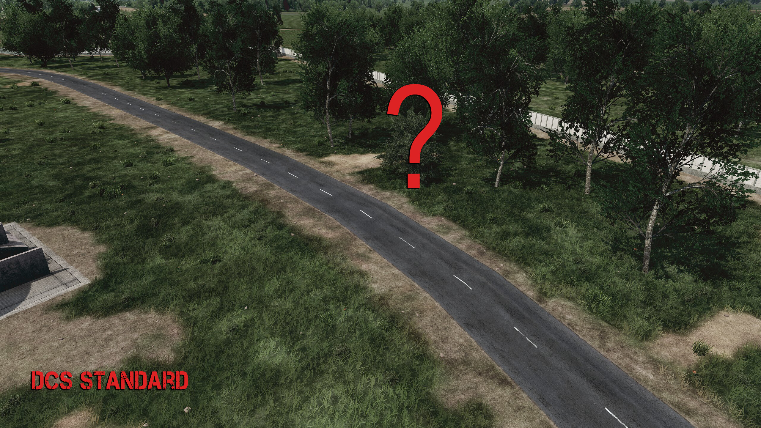
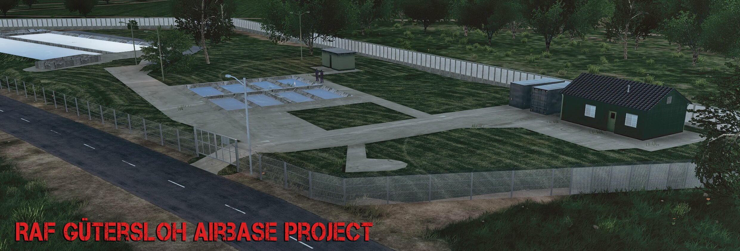
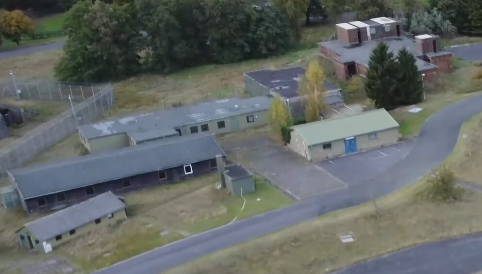
Thanks to everybody so far, pretty bussy with texturing and creating textures mostly so far, experimenting and all that.. no joke gimme that terrain editing tool and i fix most of the wrong ground detail, roads, missing lakes around Gütersloh in no time... its not that much. .. and uhm.. sorry Ugramedia...what is that building you placed at the spot where the Storage shelter should be.... here we go...
-
Gütersloh Airbase Project (Screenshots & resources)
Ghostrida9 replied to Ghostrida9's topic in DCS: Cold War Germany
@Northstar98i don't know, its again wrong on all DCS maps, changing it is probably impossible but maybe some new objects can be classified as Warehouses... Big southern storage warehouse model done, it's located in the south east shelter complex
-
the knee high "killer grass" is super annoying, a problem on all DCS maps, it's embedded into the large scenery file so not much we can do, they need to finally reduce that grass in height by 80%...
-
Gütersloh Airbase Project (Screenshots & resources)
Ghostrida9 replied to Ghostrida9's topic in DCS: Cold War Germany
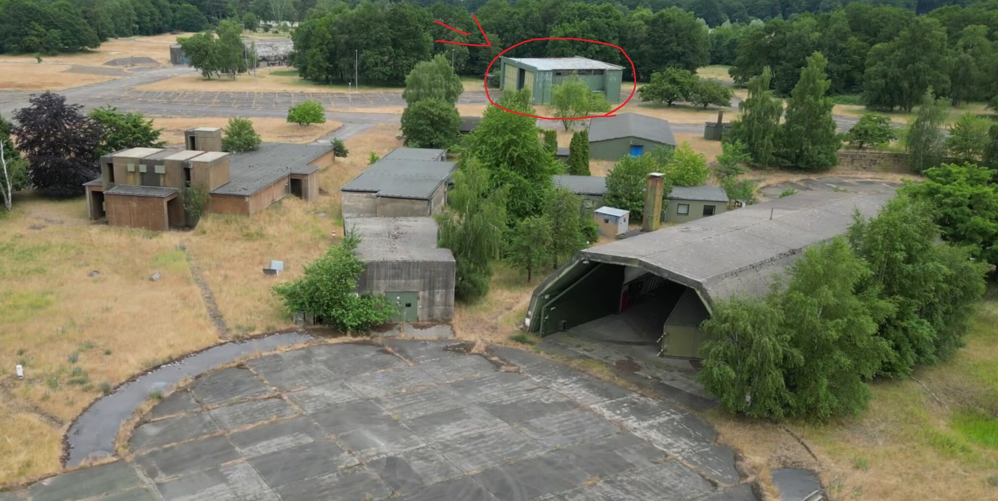
Thanks @EvilBert VR, i guess u forgot to add the link tho.. For some strange reason the bunker area / weapons bunker area is pretty much incomplete, most bunkers are missing and for some strange reason they placed those 2 weird looking world war 2 buildings into the area... also the knee high killer grass is making everything much more difficult to mod... i still hope that will be fixed, it's one of the most annonying things in all DCS maps.. i worked on those storage buildings today, including texture, normal map, AO... and added the protection walls, just the grass texture need to be fixed so it blends in with the ground much better...
-
Kindly ensure that the grass is significantly shorter on all airfield, its the return of the "plus knee high" killer grass which is far from beeing accurate. Might be nice for a horror movie but not a flight sim... it's at most just foot-high. And NO, turning the grass OFF is not an option.. THANX
-
- 9
-
-
Gütersloh Airbase Project (Screenshots & resources)
Ghostrida9 replied to Ghostrida9's topic in DCS: Cold War Germany
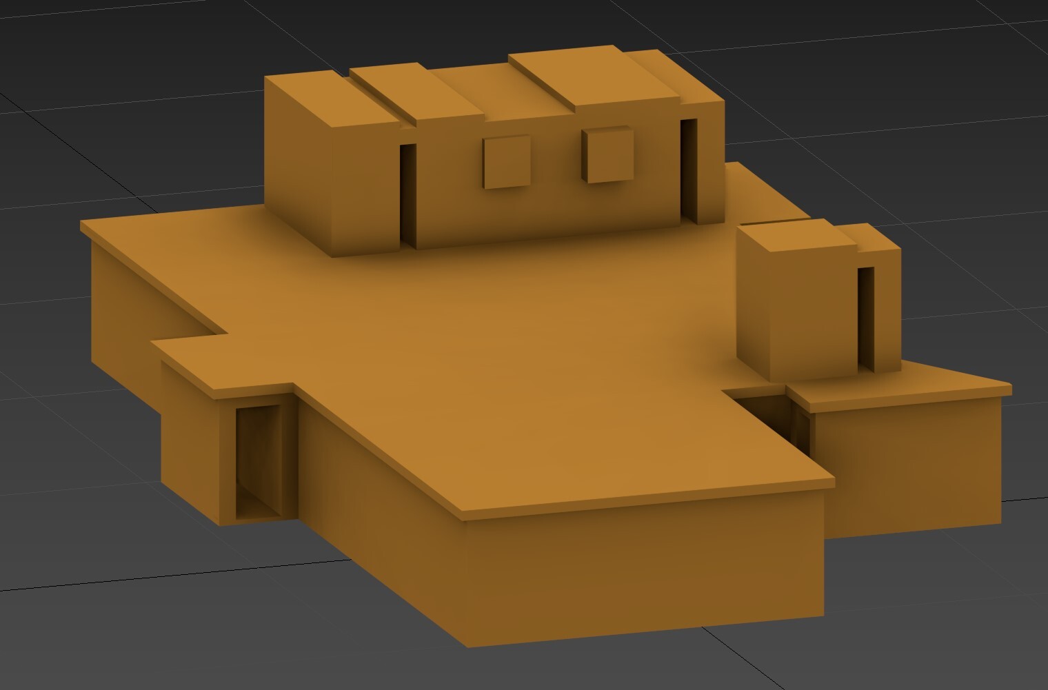
Thanks @Manschy, @flanker1 Thanks, time will tell, it's all interesting but i try to do the whole base, and since 99% of the buildings is incorrect... you get my point, it takes aloooot of time. Small update, worked hard to get the correct brownish concrete bunker texture done in Photoshop
-
Gütersloh Airbase Project (Screenshots & resources)
Ghostrida9 replied to Ghostrida9's topic in DCS: Cold War Germany
Yes @Manschy, i have a very busy and crazy life, sooner or later it will not work without a donation page seriously. its a tremendous effort to create all this... RAF Brüggen... nice... @Tengah it all depends, there's 80% undone of Gütersloh for now so... lets wait and see how people react, support and what UGRA Media does... again the Aircraft shelters are of no use right now since you can not use that parking spot nomore, they need to implement the shelter... or ED makes the KI "smarter". I have a personal connection to RAF Brüggen. Back then, some of my relatives lived just 35 kilometers (22 miles) from the Brüggen Airbase. The full story is too long to tell, but it came to a swift and sorrowful end. Yes, I was that little boy in the mid-90s, standing by the fence of RAF Brüggen with his bicycle and analog camera, watching the Tornados fly with awe, often until the very end of the day’s operations. A world that no longer exists. memeories long ago..I never went back. Anyway... Ugra created way way to many buildings around the gates, every Airbase has 1 Maingate and maybe a second gate that might open for some type of maneuvers/operations. (I had to laugh when i saw the eagle head on the western gate ) The rest are "Crash gates". I created one, nit detail, each gate might have its own number.. i think i found an easy way.. fences and guard booth are from older projects, then i finished the model for the "bunker" type building which is located in the western and southern shelter area, plus simple model for one of the office type buildings, more to follow...
-
Gütersloh Airbase Project (Screenshots & resources)
Ghostrida9 replied to Ghostrida9's topic in DCS: Cold War Germany
Thanks alot, @zsoltfireman No the GR 7 will not be part of this project, i would need 20 years probably, happy enough that we got a Harrier allready in the sim, to many flyables allready anyway IMHO. More focus on landscape and all that please !!! Thanks for the Videos, i found some nice drone footage too, and nice work @Manschy will probably come back to you sooner or later. Again this all will take a lot of time. For Now, i think i found the right military RAF green building/concrete/plaster type texture i guess, and started to work on the buildings in the western shelter area..
-
Bought this map 2 days ago. First off, thank you for doing this, UGRA! I know I'm early with this, since a lot will hopefully be added or fixed, but anyway, here we go again... I decided to get back into modding as much as possible. I know I never really finished what I started back then, but I can say I learned a lot. This time it feels different, because it's Germany — I live here on the westide if germany, grew up here, and know many of the bases since I was a little kid in the early '90s. So there's a personal connection to it to some degree. (Even if LA is my second home.) This isn't meant to bash anyone, but I did pay $55 for this map, so yeah — while I don't expect much accurate cities or villages (it's not possible without satellite data or AI generating detailed roadmaps and building placements), I do at least expect the airbases to be accurate. Right now, RAF Gütersloh looks like a civilian airport, with 99% inaccurate buildings. Also, the shelters are wrong — too many colorful buildings and so on. It's fun to have a bike at all the main gates, but I'd prefer accuracy over little details like that. So, I decided to start this project. And yes, it will take time and resources — I'm on my own doing this. More about that later. This is just a start — models are not finished yet, it's all work in progress. The only thing that's finished right now is the shelter concrete texture. Sad thing already: the AI gets scared when you place something "over" their "heads" — jets automatically choose the next available ramp start spot to take off from, even though the shelters don't even have a collision shell yet. Choosing ground start is no option since the Harrier go full speed and just crash somewhere.. very buggy So the idea with Shelters is, to some degree, useless until one of the following happens: - UGRA Media adopts my hardened shelter model, - or they create their own, - or ED tweaks the AI so they're less "scared". (Also hoping the scenery remove object tool gets enhanced too.) enough talk for now... very early stages shots
- 50 replies
-
- 12
-
-
-
I hope that we don`t get knee high grass on airports/airbases again, and i hope that Orbx use accurate satellite images on airports and airbases with at least accurate placed vegetation and access ways to buildings. I know that they can not create every single building accurate and it will be some copy/paste stuff again but moders like me can at least create those missing buildings and replace inaccurate stuff with the scenery removal tool. All other DCS Maps failed miserably regarding all this issues, and i bought all of`em. Hope is up for Kola Map..
-
Don't care about more Airfields, just fix the ground Detail on all allready existing airfield according to real life maps. Right now they all look extremely outdated. Maybe shops and gas stations in cities would be nice too. So it can more be called Sinai map, right now it's more fictional Sinai map. Sure we'll never get a ground detail that accurate like MSFS but i got my hopes up.
-
Thank you, very busy right now with some other things in life but still working on models and stuff. The major problem as mentioned before is the mostly incorrect or missing ground Detail. That makes it pretty difficult. Not a fan of placing a relevant building somewhere in the grass.. Also the Height map on OVDA is wrong.. but anyway.. some of the many OVDA Airbase models based on real images/satellite.
-
Don't know if this is mentioned @OnReTech but it seems the problem is only with the New F-15E Model, it's not placed correctly in the center inside the HAS, the HAS Model itself is correct, no problem with the F-15C. So it might be a bug of the New F-15E Module not Sinai map..
-
- 3
-
-
-
I hope that you can add higher and more accurate ground textures, (based on real satellite images), to all airfields and clear all the small objects from the 'brighter' areas, as in real life, those areas are roads, buildings, or parking lots. Please remove all bushes, rocks, and grass from those areas. It would greatly assist modders like myself. If you can also add the missing roads to those spots, that would be even better, but it's not necessary in my opinion. @OnReTech Example:
-
- 2
-